


Via Francigena of the Susa Valley from Monginevro


The itinerary continues along the asphalt road: just outside Oulx you pass the hamlet of Gad, then follow the signs for the Sentiero dei Franchi (a mountain hiking trail that leads to the Sacra di San...
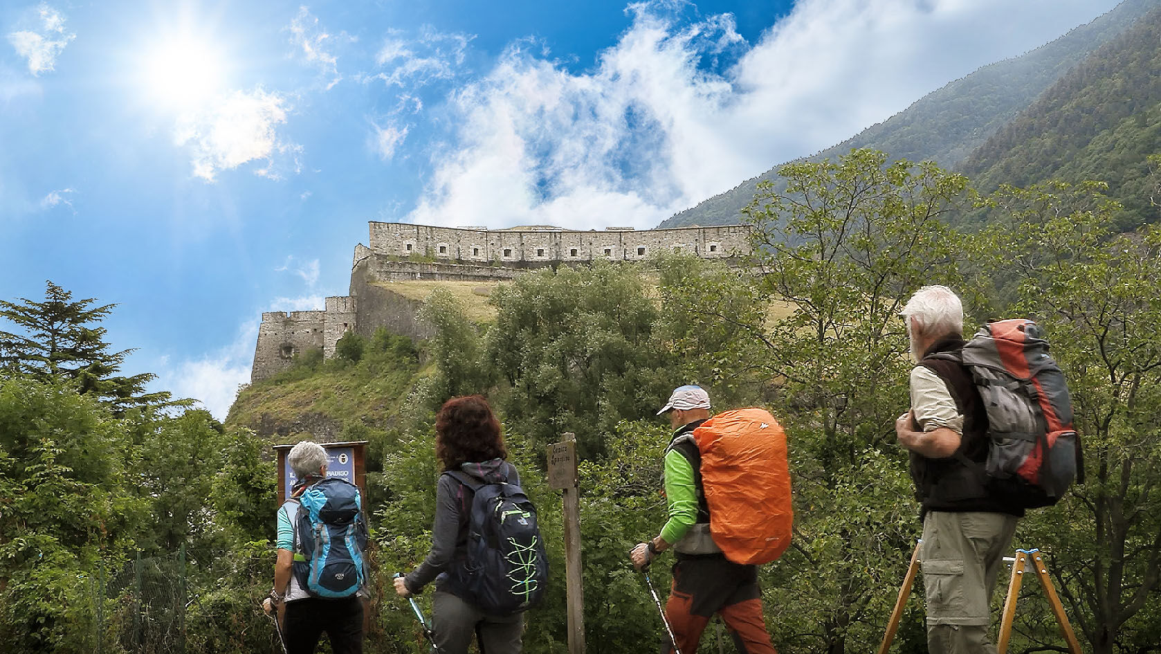
The itinerary continues along the asphalt road: just outside Oulx you pass the hamlet of Gad, then follow the signs for the Sentiero dei Franchi (a mountain hiking trail that leads to the Sacra di San Michele) until you reach the turnoff for Salbertrand: the town is home to the Gran Bosco Natural Park, one of the largest white fir forests in Europe, and the Colombano Romean Ecomuseum, which includes a visit to the splendid 16th-century frescoes in the parish church of San Giovanni Battista and the chapel of San Cristoforo in the hamlet of Oulme.Continuing along the Sentiero dei Franchi you reach the hamlet of Sapè, from which you turn off to descend to Exilles, a village characterised by intact Alpine architecture in stone and wood and dominated by the imposing Fort of the same name (12th century). In the central square stand the Romanesque bell tower and the parish church of San Pietro Apostolo, with a rich high altar from 1681; Also interesting is the small Chapel of San Rocco at the exit of the village, perhaps the result of a remodeling of a pre-existing building.The walk continues on the road parallel to the state road towards the hamlet of Cels and reaches the entrance to the hamlet of Le Ramats near the chapel of Sant’Andrea, where a suggestive path begins among the terraces of the vineyards of Avanà, a native vine, which leads to Chiomonte, once the summer residence of the Bishop of Pinerolo: the historic center is an extraordinary jewel of courtyards, porticoes, alleys and ancient noble palaces such as Casa Ronsil and Palazzo Levis, home to the Pinacoteca Civica; the chapel of Santa Caterina, once dedicated to the Baptist, is what remains of the hospital of Jerusalem: decorated internally in the Baroque period, there are fragmentary frescoes from the 14th century, while the exterior features ornaments with hanging arches and a 13th-century polylobed portal. The parish church of Santa Maria Assunta, flanked by a majestic bell tower in the Romanesque-Delphine style, features fine wooden furnishings typical of the Alpine Baroque, such as the choir and the pastoral chair, works by Jacques Jesse of Embrun, the main door by Eymon Lord, the retable with twisted columns of the altar of the Rosary (1682) by Cheffrey Faure.From the locality of San Giuseppe, continue along the Via dell’Avanà, near the deviation for the Museum and archaeological area of Maddalena; then go down towards the motorway viaduct and take the flat dirt road of the GTA route to the hamlets of Giaglione. Situated on a panoramic hill, the parish church of San Vincenzo (11th century) features a Baroque furnishing style with interesting sculptural groups attributable to the workshops from beyond the Alps. Here, as in Venaus, during the patronal feast the Spadonari with the famous Sword Dance accompany the procession of the priores with the bran, a branch decorated with lace, flowers and colored ribbons, a tradition that can be traced back to rural rites for the fertility of the fields. The path passes through the heart of the village of the same name, where the chapel of Santo Stefano stands, decorated with the famous cycle of fifteenth-century frescoes depicting the Cavalcade of Vices and Virtues; you then descend along the main road to the intersection with the SS25, just downstream from the Passeggeri locality and the confluence with the Moncenisio route.

Tururi populare în vecinătate
-
5,0
BARDONECCHIA Decauville
luminăExcursie 7,29 km -
BARDONECCHIA Colle Sommeiller
mediuMountainbike 25,4 km -
SESTRIERE Assietta Road
mediuMountainbike 43,3 km -
La Via dei Saraceni (Sauze d'Oulx)
mediuMountainbike 33,6 km -
BARDONECCHIA Decauville - Rifugio Scarfiotti Ring
luminăMountainbike 34,0 km -
Sentiero Italia: Salbertrand - Bardonecchia
mediuExcursie 19,5 km -
5,0
BARDONECCHIA Forte Jafferau Ring
greleMountainbike 36,8 km -
Jouvenceaux-Gad/Cotantin (n°9)
luminăExcursie 2,82 km -
BARDONECCHIA Forte Foens - Galleria dei Saraceni - Forte Pramand
mediuMountainbike 34,3 km -
Gad-Monfol-Ferro di Cavallo
mediuExcursie 4,38 km
Drumeții și urmărire


Nu ratați ofertele și inspirația pentru următoarea dvs. vacanță
Adresa dvs. de e-mail a fost adăugat la lista de corespondență.