Iarna
Vară
Vreme
Camere web
Cazări
Circuite
Istoric de căutare
Sugestii de căutare
Nu s-au găsit rezultate
Căutare
Circuite
Acasă
Vară Österreich
Districtul de Vest austriac Vorarlberg
Circuite
Mottakopf
Zone de schi
Parcuri de zăpadă
Schi fond
Vreme
Camere web
Raport de ninsori
Cazări
Oferte
Furnizor de sport
Evenimente
Vară
Circuite
Mottakopf
Hiking
Bookmark
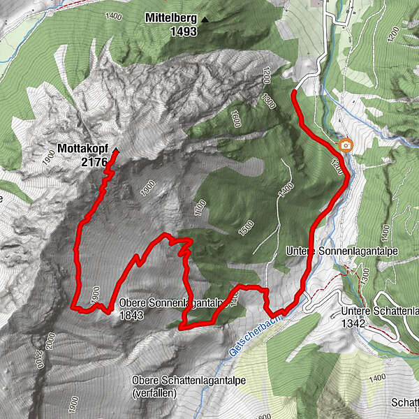
Hartă
arată
ascundeți
Imprimare
Informaţii pentru tur
5,88
km
- 2.176
m
Distanz
1.074
hm
19
hm
Ascent
01:49
h
Durata
Dominik Rauter 1
creat am 22.07.2019
11
Apeluri
(Stare: neoficial)
Cel mai înalt punct
2.176 m
Raport de turneu
GPS Downloads
GPX
GPS Exchange Format (XML)
KML
Google Earth, Google Maps
Coduri de descărcare QR pentru telefoane mobile
Mottakopf
Coduri QR - Descărcare turistică pentru telefoane mobile
GPX
KML
Mai multe tururi în regiuni
Heidiland
2201
Brandnertal
1568
Brand
431
Tururi populare în zonă
Lünersee Rundweg
uşor
7,59
km |
188
hm |
05:00
h
Fürstin-Gina-Weg
10,68
km |
850
hm |
05:00
h
Schesaplana, 2.965 m | Brand
greu
13,59
km |
1351
hm |
06:30
h
Douglashütte - Schesaplana
mediu
7,31
km |
1320
hm |
06:00
h
Nu s-au găsit intrări.
Căutarea nu este disponibilă în prezent.
Vă rugăm să vă raționalizați căutarea.
Rezultatele căutării locale
(<= 25km)
Mai multe rezultate ale căutării
(> 25km)
%count% Rezultatele căutării
%name%
%type%
%elevation%
%population%
%lpButton%