Iarna
Vară
Vreme
Camere web
Cazări
Circuite
Istoric de căutare
Sugestii de căutare
Nu s-au găsit rezultate
Căutare
Circuite
Acasă
Vară Österreich
Districtul de Vest austriac Vorarlberg
Circuite
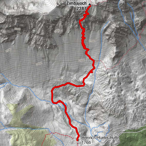
Zimbajoch-Heinrich Hüter Hütte
Zone de schi
Parcuri de zăpadă
Schi fond
Vreme
Camere web
Raport de ninsori
Cazări
Oferte
Furnizor de sport
Evenimente
Vară
Circuite
Zimbajoch-Heinrich Hüter Hütte
Hiking
Bookmark
Hartă
arată
ascundeți
Imprimare
Informaţii pentru tur
2,4
km
- 2.382
m
Distanz
36
hm
651
hm
Ascent
00:33
h
Durata
Matthias Brehm
creat am 18.07.2019
5
Apeluri
(Stare: neoficial)
Cel mai înalt punct
2.382 m
Raport de turneu
GPS Downloads
GPX
GPS Exchange Format (XML)
KML
Google Earth, Google Maps
Coduri de descărcare QR pentru telefoane mobile
Zimbajoch-Heinrich Hüter Hütte
Coduri QR - Descărcare turistică pentru telefoane mobile
GPX
KML
Mai multe tururi în regiuni
Appenzellerland
1956
Brandnertal
1568
Brand
431
Tururi populare în zonă
Üble Schlucht / Laterns
mediu
6,3
km |
322
hm |
02:30
h
Rundtour Nenzinger Himmel - Setschalpe - Hirschsee
mediu
6,84
km |
406
hm |
03:30
h
Around Lake Formarin
greu
3,79
km |
84
hm |
02:06
h
Rote Wand 2704m
greu
13,9
km |
1181
hm |
06:00
h
Nu s-au găsit intrări.
Căutarea nu este disponibilă în prezent.
Vă rugăm să vă raționalizați căutarea.
Rezultatele căutării locale
(<= 25km)
Mai multe rezultate ale căutării
(> 25km)
%count% Rezultatele căutării
%name%
%type%
%elevation%
%population%
%lpButton%