© Oststeiermark Tourismus - Christine Pollhammer

© Oststeiermark Tourismus - Christine Pollhammer

© Oststeiermark Tourismus - Christine Pollhammer

© Oststeiermark Tourismus - Christine Pollhammer

© Oststeiermark Tourismus - Christine Pollhammer

© Oststeiermark Tourismus - Christine Pollhammer

© Oststeiermark Tourismus - Christine Pollhammer

© Oststeiermark Tourismus - Christine Pollhammer

© Oststeiermark Tourismus - Christine Pollhammer

© Oststeiermark Tourismus - Christine Pollhammer

- Scurtă descriere
-
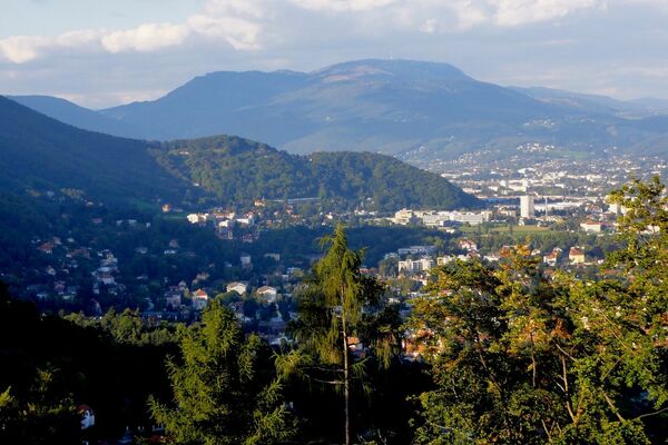
With its 1,445 m, the Schöckl is one of the highest elevations in the Almenland Nature Park in Styria. The easy tour leads from the Schöckl cross up to the summit plateau.
- Greutăţi
-
uşor
- Evaluare
-
- Ruta
-
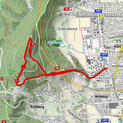
Schöckl (1.445 m)2,6 kmGipfelkreuz Schöckl2,8 kmStoawandhütte3,0 kmStubenberghaus3,7 kmSchöckl3,8 kmSchöneben4,9 kmSchöcklkreuz (1.125 m)7,8 km
- Cel mai bun sezon
-
ianfebmaraprmaiiuniulaugsepoctnovdec
- Cel mai înalt punct
- 1.442 m
- Destinație
-
Schöckl Cross
- Profil de elevație
-


-

-
AutorTurul Schöckl Round from Schöcklkreuz (Plenzengreith) este utilizat de outdooractive.com furnizat.
GPS Downloads


Informaţii generale
Oprire pentru băuturi răcoritoare
Promițător
Mai multe tururi în regiuni
-
Erlebnisregion Graz
2782
-
Grazer Bergland - Schöcklland
1702
-
Schöckl
622