© Erlebnisregion Schladming-Dachstein - Roland Gutwenger

- Scurtă descriere
-
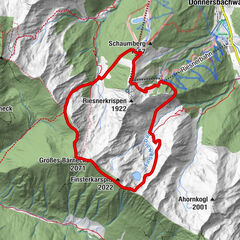
First four kilometers with only short climbs form the ideal warm-up phase before we overcome about 220 m in the Raumberg forest on forest and hiking trails and reach our highest point, the Obermoserhof. Here we are rewarded with a surprising panoramic view. The downhill on first asphalt and then forest hiking trails brings us back to the starting point via the Fischersteig.
- Greutăţi
-
uşor
- Evaluare
-
- Ruta
-
Raumberg3,8 kmSagschachengraben8,5 km
- Cel mai bun sezon
-
ianfebmaraprmaiiuniulaugsepoctnovdec
- Cel mai înalt punct
- 1.006 m
- Destinație
-
Gasthof Rüscher
- Profil de elevație
-


-

-
AutorTurul Obermoser Trail este utilizat de outdooractive.com furnizat.
GPS Downloads


Mai multe tururi în regiuni