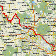
Sport and recreation hike on the left bank of the river Elbe valleys


© Thomas Jänicke - Torsten Schröder

- Scurtă descriere
-
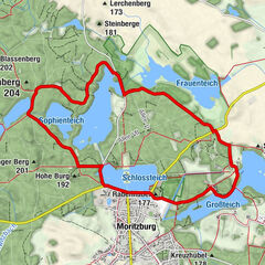
Hike between Squirrel Ground and Saubach Valley
- Greutăţi
-
mediu
- Evaluare
-
- Ruta
-
Coswig (118 m)0,3 kmGauernitz1,1 kmPinkowitz2,6 kmRöhrsdorf5,8 kmSt.-Bartholomäus-Kirche6,0 kmConstappel11,0 kmCoswig (118 m)12,0 km
- Cel mai bun sezon
-
ianfebmaraprmaiiuniulaugsepoctnovdec
- Cel mai înalt punct
- 255 m
- Destinație
-
Elbe ferry Coswig/Kötitz
- Profil de elevație
-
 © outdooractive.com
- Autor
-
Turul Sport and recreation hike on the left bank of the river Elbe valleys este utilizat de outdooractive.com furnizat.
GPS Downloads


Informaţii generale
Cultural/Istoric
Promițător
Mai multe tururi în regiuni
-
Dresden Elbland
624
-
Dresden
575
-
Klipphausen
144