Passing through the southern Oberaargau alongside proud farmhouses


- Scurtă descriere
-
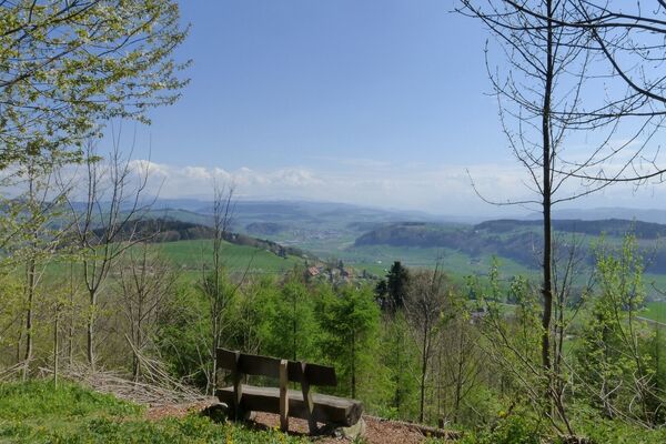
One of the most beautiful high-altitude hikes across the undulating hills of the southern Oberaargau. The hills in the triangle between Langete, Rotbach and Öschenbach not only offer delightful views of the Mittelland and Jura, as well as into the foothills of the Alps and Alpine world, but the views down into the tranquil, wooded valleys are equally impressive. The pleasingly-designed farmhouses along the way, with their huge hipped roofs and inviting frontages are particularly charming. They emanate something of the sense of peace and secureness that we seem to be increasingly lacking today. Hard-surfaced paths near settlements.
- Greutăţi
-
mediu
- Evaluare
-
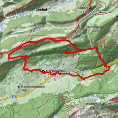
- Ruta
-
Hotel BärenDürrenrothHueberhof0,0 kmChipf0,1 kmDürrenroth0,1 kmRestaurant Bahnhof0,3 kmMüli0,3 kmMühlehof0,4 kmTschättebach0,4 kmChabisberg1,0 kmGanzenberg3,0 kmKiltbächli3,6 kmWeid3,9 kmObere Matten4,3 kmAeschi4,8 kmGschwend5,9 kmScheine6,6 kmDorfmühle6,8 kmGerbestock6,8 kmSagihüsli6,9 kmGerbe6,9 kmUrsenbach7,0 kmReformierte Kirche7,0 kmHohlen7,1 kmOberdorf7,1 kmKehr7,2 kmOberdorf7,4 kmKaiser7,9 kmWolfacker8,1 kmHübeli8,7 kmSonnheim9,3 kmFreihof9,4 kmWalterswil9,5 kmEgg9,6 kmHasennest9,9 kmHöhe10,0 kmNeuhaus10,1 kmBrestenberg10,6 kmGründen11,2 kmMussachen12,2 kmMuessache12,4 kmGärbihof13,7 kmGärbihof13,9 kmNeuhus14,1 kmSparhof14,2 kmChipf14,3 kmHotel Bären14,3 kmDürrenroth14,3 km
- Cel mai bun sezon
-
ianfebmaraprmaiiuniulaugsepoctnovdec
- Cel mai înalt punct
- 832 m
- Destinație
-
Dürrenroth
- Profil de elevație
-
 © outdooractive.com

-

-
AutorTurul Passing through the southern Oberaargau alongside proud farmhouses este utilizat de outdooractive.com furnizat.
GPS Downloads


Informaţii generale
Oprire pentru băuturi răcoritoare
Mai multe tururi în regiuni
-
Solothurn und Region
1453
-
Oberaargau
718
-
Rohrbach BE
147